
Oğuz Cem Demirci

Civil Engineer · M.Sc. Student, Transportation Engineering, METU

Academic Profile

Research Interests

  • Project Controls
  • Schedule Management
  • Progress Monitoring
  • Digital Project Delivery
  • Project Management Information Systems (PMIS)
  • Transportation Infrastructure Projects
  • Transportation Network Vulnerability
  • Emergency Accessibility
  • Earthquake-Induced Network Disruption
  • Digital Twin decision support

Current Research

M.Sc. thesis · proposal stage · 2026

Earthquake-Induced Transportation Network Disruption, Emergency Accessibility and Vulnerability

A district-level study using a scenario-based Digital Twin decision-support environment

When an earthquake damages or blocks parts of an urban road network, travel times change and some locations can be cut off from emergency services. My thesis focuses on this transportation-level problem: it compares the baseline road network with earthquake-disrupted network states, measures the resulting loss of emergency accessibility, and uses that loss to find the most vulnerable routes, areas and network components.

Study area
A selected urban district
Focus
Immediate post-earthquake emergency response
Methods
GIS network analysis, shortest-path travel time, reachability

Research questions

  1. RQ1How does an earthquake-induced transportation network disruption affect emergency accessibility in the study district?
  2. RQ2How do baseline and disrupted network conditions differ in travel time and reachability to critical facilities?
  3. RQ3Which OD relationships, areas or network components lose the most accessibility, and are therefore most vulnerable from an emergency-access perspective?
  4. RQ4How can the network, disruption scenarios and results be represented in a scenario-based Digital Twin decision-support environment?

Research framework

  1. DataRoad network, critical facilities, earthquake data
  2. Baseline networkClean, standardize, topology + travel-time impedance
  3. Emergency accessibilityFire station → building, building → hospital
  4. Earthquake disruptionScenario: affected or impaired links and nodes
  5. Disrupted accessibilitySame OD pairs, same impedance, recalculated
  6. VulnerabilityAccessibility loss, travel-time increase, reachability loss
  7. Digital TwinScenario selection, comparison, visualization

How emergency accessibility is measured

FS B H Fire station Risk-prone building Hospital closed by earthquake
Baseline route Detour after disruption
OD 1Fire station → risk-prone building
OD 2Risk-prone building → hospital

Both relationships are measured on the same network, first in its baseline state and then under the earthquake scenario, using the same OD pairs and the same travel-time impedance.

  • Travel-Time Increase
  • Reachability Loss
  • Spatial Impact

Digital Twin decision support

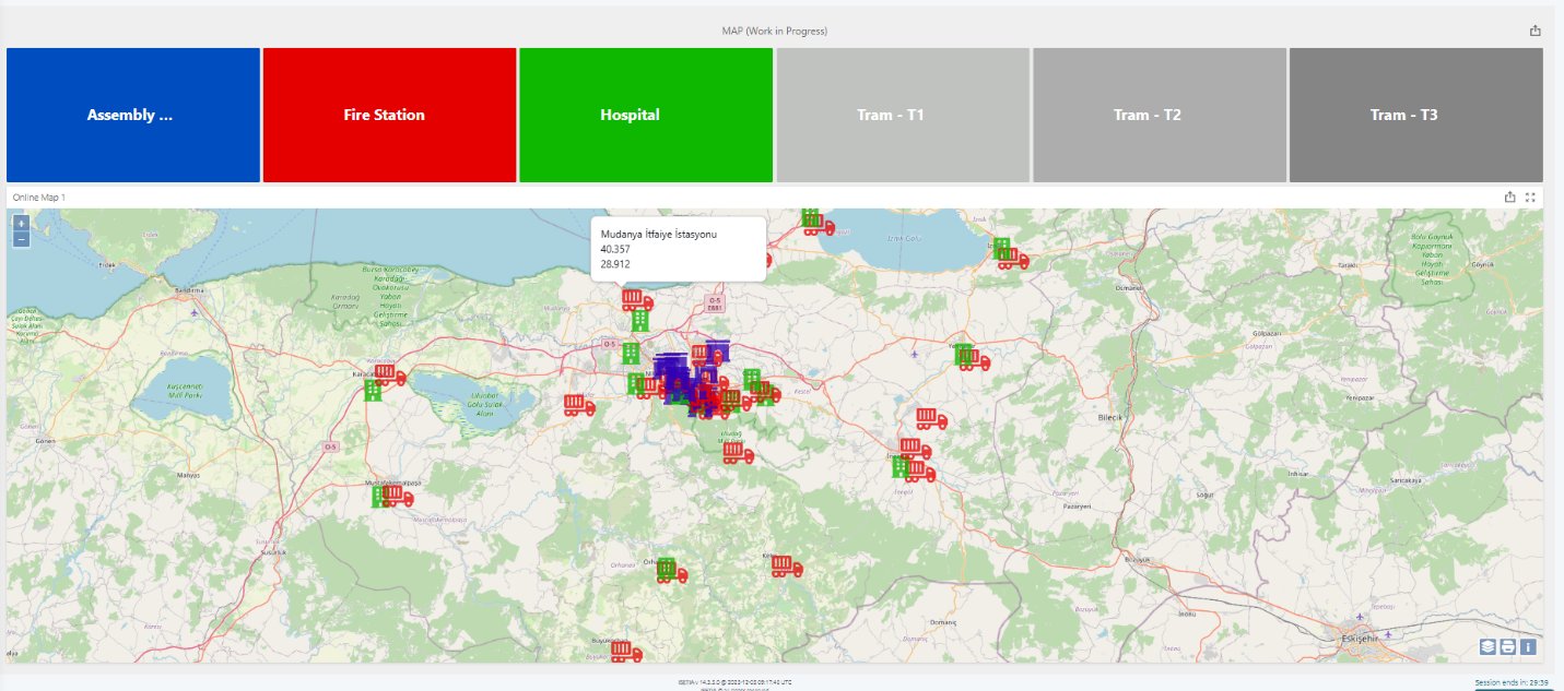
Map-based Digital Twin interface showing critical facilities such as fire stations and hospitals on a city map
Digital Twin-based map interface for critical facility visualization, from my GGIT590 seminar report (METU, 2026). In the thesis, the same environment will let users select a scenario and compare baseline and disrupted accessibility.

Education

M.Sc. in Transportation Engineering

2025 – Present Middle East Technical University (METU), Department of Civil Engineering, Ankara

B.Sc. in Civil Engineering

2017 – 2022 Çankaya University, Ankara

High School Diploma

Ankara Lisesi (Anadolu), Ankara

Academic Identifiers

ORCID iD
0009-0009-1147-6163
Google Scholar
scholar.google.com/citations?user=y61YrUIAAAAJ
Affiliation
Middle East Technical University (METU)

Publications

Publications will be listed here as they appear. See my Google Scholar profile for the latest record.